
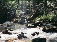
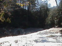
Slickrock Creek lies within the Joyce Kilmer-Slickrock Wilderness area which was designated a wilderness by the 1975 wilderness Act. Slickrock Creek starts in the Unicoi Mountains of southwestern North Carolina and southeastern Tennessee and it follows the state boundary for its entire length before the confluence with the Little Tennessee River below the Cheoah Dam. The stream is properly named as it is especially slippery which indicates that the pH is adequate to support good trout.
Slickrock Creek Trail, follows the creek for some 13 miles and is accessible from the Ike Branch Trail immediately below the Cheoah Dam. This is the easiest way to access the stream with an elevation change from 1000 feet up to about 2000 feet. However, there are ten stream crossings and one spot where the narrow path goes crosses a rock ledge approximately 8 feet above the stream. This spot I well remember as the spot where I sprained my knee when my backpack shifted.
An alternative is to take the Big Fat Gap trail. To reach the Big Fat Gap trailhead take Forest Service Road 82 off U.S. Highway 129 out of Robbinsville and follow the narrow gravel road for several miles. Take Forest Service Trail 41 to the parking area. The trail from the parking area to Slickrock Creek drops from 3,000 feet to 2,000 feet within 1 ½ miles making it easy going down but difficult to return, so be prepared for some serious exercise.
Fishing Slickrock:
After about 2 to 3 hours of hiking you will find the most beautiful Wildcat Falls with a pool where large browns abound. Due to its remote location, I have fished Slickrock only on three occasions and I do not recall seeing any rainbow trout. The fickle browns however, are the most colorful and prettiest browns that can be found in North Carolina. Fishing for the magnificent browns can be accomplished by a number of ways including yellow rooster tail in-line spinners, countdown rapalas, and super duper lures. For fly fishing, Green Drake hatch in April or May will sure provide great fishing. Yellowhammer flies are productive all year.
Spring:
Springtime is prime time on the Slickrock Creek as we will start to see a few hatches of mayflies and the stoneflies.
Good choices are to start with nymphs in the Hendrickson, March brown and greendrake patterns.
Summer:
The summer months remain good but the hickers are more frequent. Good flies for summer are the little stoneflies and cream cahills as well as numerous terrestrials including the yellowhammer.
Fall:
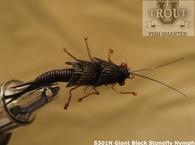
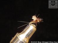
Autumn provides the next best time to fish the Slickrock Creek for browns. Blue Winged Olives, Giant Black Stoneflies, and Midges are effective.
Winter:
Midges represent the bulk of the aquatic insect food supply, but there are hatches of Blue Winged Olives, Blue Quills and Quill Gordons. Streamers will be a good choice especially for the faster waters.
NOTE: If you have any suggestions to improve or to add to this information please use the Contact Form to do so.
Slickrock Creek is easily accessible from the Slickrock Creek Trail with directions below.
Slickrock Creek Trail is located about 15 miles north of Robbinsville on U.S. 129 North. As you travel north on U.S. 129 you will be driving above Santeetlah Lake. Then the road turns down hill and parallels the Cheoah River. Within a half mile of crossing the Cheoah River at the Tapoco area, you will arrive at the south side of the Cheoah Dam. Turn left off of the highway onto a dirt service road before crossing the dam. This is the trailhead and their is adequate parking just after turning off the highway.
To reach the Big Fat Gap trailhead take Forest Service Road 82 off U.S. Highway 129 out of Robbinsville and follow the narrow gravel road for several miles. Take Forest Service Trail 41 to the parking area.
Trout University free classes, free videos, dozens of tips and instructional DVDs.
Recommended DVDs:
Tennessee State Regulations
North Carolina License
Chart for Slickrock Creek
View Southeast USA in a larger map